Uncategorized
Recent Ring of Fire Earthquakes: What They Really Mean
Editorial illustration created for HFD.
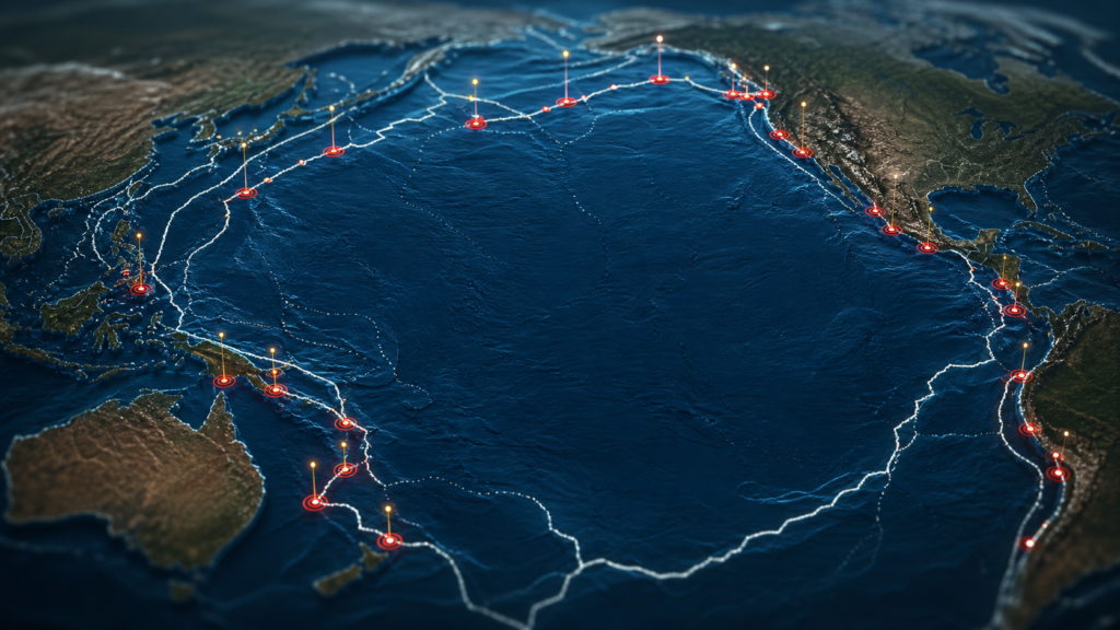
Open an earthquake map on the wrong day and the Pacific can look like it is lighting up.
A marker near Japan. Another near Chile. A cluster around Indonesia. A deep quake near Tonga. A headline from Alaska. A smaller event in California that everyone notices because people live nearby and phones buzz.
The human brain does what it is built to do. It connects dots.
Sometimes that helps. Sometimes it turns a map into a prophecy.
The Pacific Ring of Fire is one of the most active seismic regions on Earth, but it is not a single crack running around the ocean. It is not one giant fault waiting to unzip. It is not a countdown clock. It is a long, uneven system of plate boundaries where pieces of Earth’s outer shell collide, slide, dive and lock together until stress finally breaks loose.
So when recent Ring of Fire earthquakes appear close together in the news, the right question is not whether the region is “waking up.”
It was never sleeping.
The better question is what the data actually shows, and what it does not.
The Ring Looks Like a Pattern Because the Planet Built One
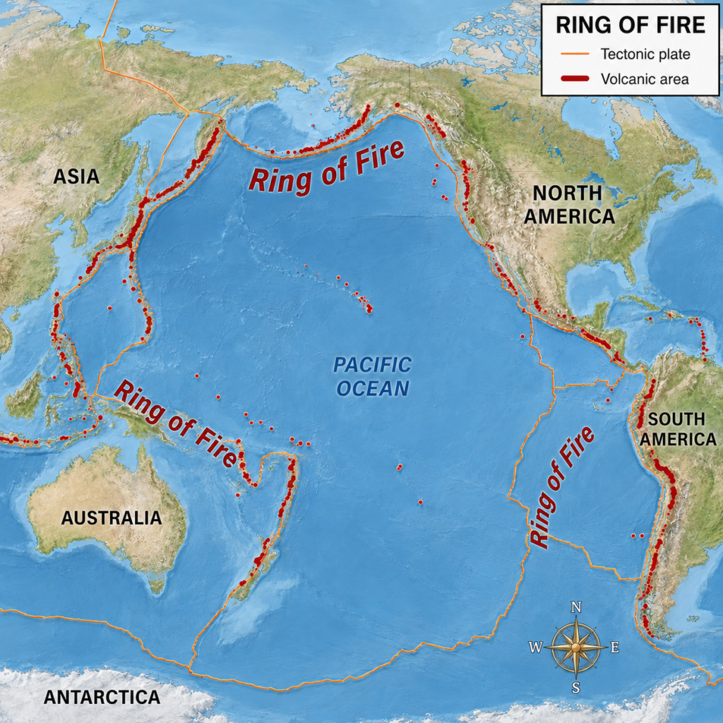
The Ring of Fire is often described as a horseshoe around the Pacific Ocean. That image is useful, but only up to a point.
It runs along the western coasts of South and North America, through Alaska and the Aleutian Islands, across the western Pacific near Japan, the Philippines, Indonesia, Papua New Guinea and down toward New Zealand. On a map, that arc looks almost intentional, as if the planet drew a warning sign around the Pacific.
Geologically, it is messier and more interesting.
The Ring of Fire is not one structure. It is a collection of subduction zones, ocean trenches, volcanic arcs, transform faults and collision zones. Some parts are dominated by one tectonic plate diving beneath another. Some parts involve plates sliding sideways. Some sections produce explosive volcanoes. Others produce huge earthquakes with little or no volcanic drama at the surface.
The common thread is motion.
Earth’s outer shell is broken into plates. They move slowly, usually at rates measured in centimeters per year. That sounds gentle until you remember that the plates are carrying continents, ocean floors and mountain belts with them.
A fingernail pace can still move a planet.
Why So Many of the Largest Earthquakes Happen There
USGS describes the circum-Pacific seismic belt as the world’s greatest earthquake zone and says it contains about 81% of the world’s largest earthquakes.
That number is the beginning of the story, not the end.
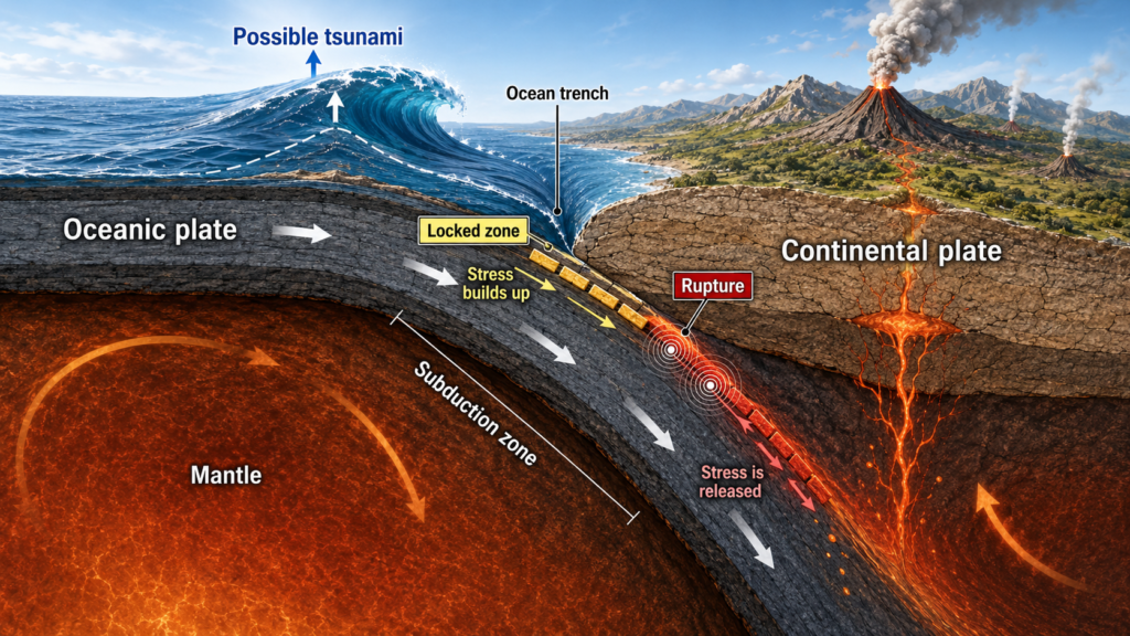
The reason is not that the Pacific is unlucky. It is that much of its edge is lined with subduction zones. A subduction zone is where one tectonic plate dives beneath another and sinks into the mantle. The diving plate does not slide smoothly all the time. It can stick. Stress builds. The boundary bends and stores energy.
Then, suddenly, part of it slips.
That sudden slip sends seismic waves through the Earth. If the rupture is large enough and shallow enough, the shaking can become catastrophic. If it happens under the ocean and moves the seafloor vertically, it can also move the water above it and generate a tsunami.
This is why so many of the largest recorded earthquakes come from the same broad family of places.
The USGS list of the 20 largest earthquakes since 1900 starts with the 1960 Chile earthquake, magnitude 9.5. Then comes the 1964 Alaska earthquake, magnitude 9.2. The list also includes the 2004 Sumatra-Andaman earthquake, the 2011 Tohoku earthquake in Japan, the 1952 Kamchatka earthquake, the 2010 Maule earthquake in Chile, the 1906 Ecuador-Colombia earthquake and the 1965 Rat Islands earthquake in Alaska.
Different coastlines. Different histories. Different human consequences.
But the same larger theme keeps returning: big earthquakes often come from big plate boundaries.
The Instrument Record Starts Late, but It Already Tells a Clear Story
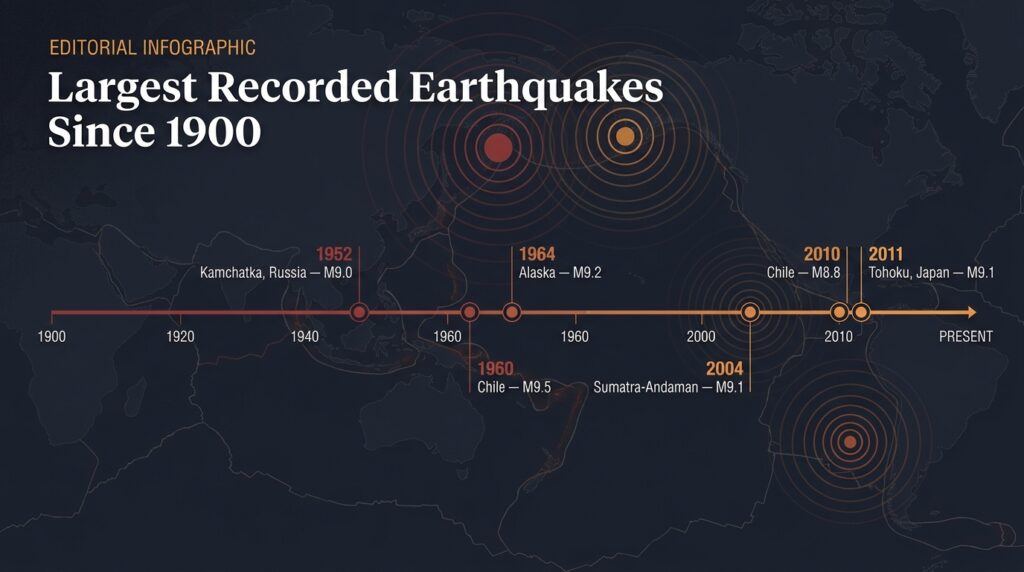
When scientists talk about the largest earthquakes “ever recorded,” they usually mean recorded by modern seismic instruments. That matters.
Earthquakes happened before 1900. Many were devastating. Some may have been enormous. But before global instrumental networks, magnitudes were often estimated from damage, historical descriptions, geologic evidence and later analysis. The further back we go, the foggier the numbers become.
That is why the USGS list since 1900 is so useful. It does not claim to describe every major earthquake in Earth’s history. It gives a more reliable window into the modern instrumental era.
And inside that window, the pattern is hard to miss.
The greatest events cluster around major plate boundaries, especially subduction zones. The Ring of Fire does not produce large earthquakes because it is mysterious. It produces them because the geometry is built for it: long faults, oceanic plates, locked interfaces and enormous areas that can rupture in one event.
A magnitude 9 earthquake is not just a “stronger” magnitude 7.
It is a different scale of rupture.
Magnitude is logarithmic. Each whole-number increase represents a huge jump in released energy. USGS explains the relationship by noting that it would take many smaller earthquakes to equal the energy of one larger one. That is why a long list of small quakes does not “relieve” a plate boundary in any simple way. The small events matter locally and scientifically, but they do not empty the system like steam from a kettle.
The Earth is not a kettle.
It is worse at scheduling.
Recent Quakes Feel Connected Because Maps Compress Distance
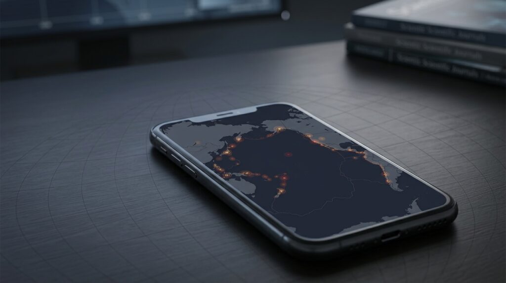
The modern earthquake map is both a scientific tool and a psychological trap.
It puts the whole planet on one screen. A quake near Japan and a quake near Chile can sit a few inches apart on your phone, even though the real distance between them is oceanic, tectonic and enormous. A busy week becomes a constellation. A constellation becomes a story.
That does not mean the story is true.
USGS addresses this directly. People often ask whether a major earthquake in one place can trigger another far away. Over long distances, the general answer is no. Earth’s rocky crust does not transfer stress efficiently enough over thousands of miles to make every distant earthquake part of one chain reaction.
There are important nuances.
Earthquakes do trigger aftershocks near the original rupture. A very large earthquake can also trigger small, short-lived seismic activity at great distances. But that is different from saying that a quake in one part of the Pacific has set off another major quake on the other side of the ocean.
In seismology, “connected” has to mean something physical.
It cannot just mean the dots looked dramatic on a map.
What a Cluster Really Can Mean
Earthquakes do not arrive evenly spaced like appointments.
Some days are quiet. Some weeks are busy. Some sequences include a mainshock and aftershocks. Some begin with what later turns out to be a foreshock. Some regions experience swarms, where many quakes occur without one obvious dominant event. And sometimes several unrelated earthquakes happen close together in time because the world is large and active.
That last explanation feels unsatisfying.
It is also often correct.
USGS worldwide statistics from 2000 through 2021 show that magnitude 8.0 and larger earthquakes varied from zero to four per year. Magnitude 7.0 to 7.9 earthquakes ranged from six to 23 per year. Magnitude 6.0 to 6.9 earthquakes usually numbered in the hundreds.
So a year with several major earthquakes is not automatically evidence of a new planetary mode. It may sit inside the observed range of modern seismic behavior.
The difficult part is emotional. A magnitude 7 near people is not just a data point. It is broken buildings, power outages, phones not connecting, families looking for each other and officials trying to understand whether the coastline is safe.
Science has to hold both truths at once.
The event may be globally ordinary.
Locally, it may be life-changing.
The Ring of Fire Is Not One Fault
One of the most useful corrections is also the simplest: the Ring of Fire cannot rupture all at once because it is not one continuous fault.
The Peru-Chile Trench is not the Japan Trench. The Aleutian system is not the Tonga-Kermadec system. The Cascadia Subduction Zone is not the Sunda megathrust. These systems share a broad tectonic theme, but they have different plate motions, locking behavior, sediment conditions, rupture histories and local hazards.
Think of the Ring of Fire less like one zipper and more like a long coastline full of separate machines, some connected by plate-scale motion, but not wired to fire in one global sequence.
That distinction matters because vague language can make the whole Pacific sound like one monster.
It is more accurate, and more useful, to think in segments.
Each segment has its own risk. Each needs its own monitoring. Each has its own history of earthquakes, tsunamis and volcanic activity. The danger is real, but it is not evenly distributed and not synchronized by headline.
Magnitude Is Only the First Number
When earthquake news breaks, magnitude gets the headline because it is easy to compare.
Magnitude 7.5 sounds bigger than 6.2. It is bigger. But danger does not come from magnitude alone.
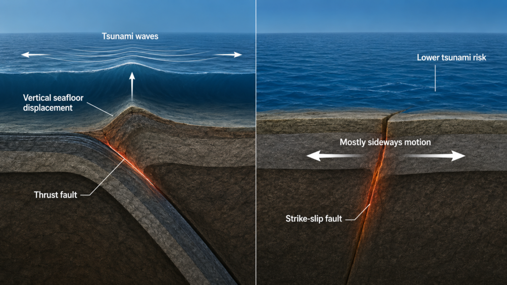
Depth matters. A shallow earthquake usually produces stronger shaking near the surface than a deeper earthquake of similar magnitude. Distance matters. A large quake far offshore may cause less building damage than a smaller quake directly beneath a city. Fault type matters. A thrust earthquake at a subduction zone behaves differently from a strike-slip earthquake where plates slide sideways.
Ground matters too.
USGS notes that local geology can amplify shaking. Soft sediments can shake more strongly and for longer than hard bedrock. That is why two neighborhoods at the same distance from the same earthquake can have different experiences.
Then there is the human layer: building codes, construction quality, population density, time of day, preparedness, warning systems and whether critical infrastructure survives the first minute.
Earthquakes do not kill by magnitude alone.
They become disasters when geology meets exposure.
Why Some Ocean Quakes Make Tsunamis and Others Do Not
Tsunami risk is one reason Ring of Fire earthquakes carry global attention.
But not every ocean earthquake makes a tsunami. The ocean does not respond to a magnitude number by itself. It responds to displacement.
The most dangerous tsunami-generating earthquakes often happen at subduction zones, where one plate suddenly lurches over another and the seafloor moves vertically. That motion can lift or drop a huge volume of water. The resulting waves can cross ocean basins at jetliner speeds and grow dangerous as they approach shallow coastlines.
A strike-slip earthquake, where plates mostly slide sideways, is usually less efficient at generating a major tsunami because it does not lift the seafloor in the same way. A deep earthquake may also produce little tsunami risk. A large offshore earthquake can trigger alerts while scientists and warning centers determine whether the seafloor actually moved enough water to threaten coastlines.
That is why official tsunami systems matter.
NOAA’s tsunami.gov does not treat “big earthquake near ocean” as the whole answer. Warning centers evaluate magnitude, depth, location, fault motion, water-level observations and forecast models.
The first minutes after a coastal quake belong to caution.
The deeper interpretation belongs to data.
Prediction Is Not the Same as Hazard
The Ring of Fire produces a steady supply of bad predictions.
Some are dressed up as secret patterns. Some point to animal behavior, weather, planetary alignments or the fact that two quakes happened close together on a calendar. Most become popular because they offer something science cannot: certainty.
USGS is blunt on this point. Scientists cannot predict the exact time, place and magnitude of a future earthquake.
That does not mean scientists know nothing. It means prediction and hazard are different.
Hazard science can identify dangerous faults, estimate long-term probabilities, model shaking, map tsunami zones, study past ruptures and improve building codes. After a major earthquake, scientists can forecast aftershock probabilities. Early warning systems can sometimes provide seconds of notice after a quake has already begun but before strong shaking arrives farther away.
That is not prophecy.
It is measurement, probability and preparation.
The distinction is less glamorous than a viral prediction. It is also the part that saves lives.
The Data Shows Restlessness, Not a Countdown
If the Ring of Fire feels unusually active, part of that feeling comes from how much better we are at seeing it.
Modern seismic networks detect earthquakes that would have gone unnoticed a century ago. Real-time maps publish events within minutes. Smartphones deliver alerts. Social media turns regional shaking into global awareness. The planet did not necessarily become louder. Our instruments did.
That does not make the risk imaginary.
It makes interpretation harder.
The data since 1900 shows that the Ring of Fire has produced many of the largest earthquakes ever measured. The data since 2000 shows that significant earthquakes vary year to year within a broad range. The physics shows why subduction zones can produce giant ruptures. The warning systems show why an offshore quake deserves immediate attention. And the limits of prediction show why certainty is the wrong product to look for.
Recent Ring of Fire earthquakes mean the Pacific rim remains what it has long been: a place where Earth’s moving plates turn slow motion into sudden violence.
That is serious enough.
It does not need mythology.
What Recent Ring of Fire Earthquakes Really Mean
They mean stress is being released somewhere along one of the planet’s most active tectonic margins.
They mean scientists should check the event details: magnitude, depth, location, fault type, shaking intensity, aftershocks and tsunami potential.
They mean people near the affected area should follow local emergency guidance.
They do not mean the entire Ring of Fire is about to rupture.
They do not mean a global chain reaction has begun.
They do not mean anyone has predicted the next major quake.
The Ring of Fire is not a warning that the planet has suddenly changed personality. It is a reminder of what the planet has been doing all along, beneath oceans and cities and mountain ranges, at the slow speed of plates and the sudden speed of rupture.
Most days, that motion is invisible.
Then a fault slips, a map lights up, and for a few minutes everyone remembers that the ground is not a fixed thing.
It is only quiet between sentences.
More science worth reading
If this kind of Earth science story interests you, our deep dive into NASA’s Perseverance rover looks at another big question: whether Mars may preserve clues of ancient microbial life.Read: Did NASA Find Signs of Ancient Life on Mars?
FAQ
What is the Ring of Fire?
The Ring of Fire is a broad zone of earthquakes and volcanoes around the Pacific Ocean. It includes many subduction zones, ocean trenches, volcanic arcs and fault systems, but it is not one single fault.
Are recent Ring of Fire earthquakes connected?
Usually, distant major earthquakes are not directly connected. Earthquakes can trigger aftershocks near the original rupture and sometimes small, short-lived distant seismicity, but that is different from a global chain reaction.
Why do so many big earthquakes happen around the Pacific?
Much of the Pacific margin is lined with subduction zones, where one tectonic plate dives beneath another. These long, locked boundaries can store and release enormous amounts of energy.
What is the largest earthquake ever recorded?
USGS lists the 1960 Chile earthquake as the largest earthquake recorded by instruments since 1900, with a magnitude of 9.5.
Can scientists predict earthquakes?
No. Scientists can identify hazard zones and estimate long-term risk, but they cannot reliably predict the exact time, place and magnitude of a future earthquake.
Does every large ocean earthquake cause a tsunami?
No. Tsunami risk depends on magnitude, depth, location, fault motion and whether the seafloor moves enough water, especially through vertical displacement.
Where should readers check current earthquake and tsunami information?
Use the USGS Latest Earthquakes map for earthquake data and NOAA’s tsunami.gov for U.S. tsunami alerts and official tsunami messages.
Sources
- USGS – Earthquake Facts & Earthquake Fantasy
- USGS – 20 Largest Earthquakes in the World Since 1900
- USGS – Lists, Maps, and Statistics
- USGS – Latest Earthquakes map
- NOAA / National Tsunami Warning Center
